Home > Arts > Artists > O > Oceanic Oceanic
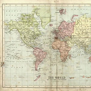
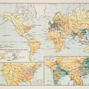
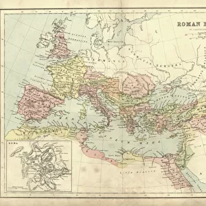
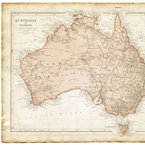
map of the world 1873

![]()
Wall Art and Photo Gifts from Fine Art Storehouse
map of the world 1873
antique map of the world - from a french atlas - 1872
Unleash your creativity and transform your space into a visual masterpiece!
THEPALMER
Media ID 21177693
© Roberto A Sanchez
Atlas Australia Backgrounds Earth Grunge North America Oceania Pacific Ocean Paper Patina Retro Revival South America Stained Textured Effect The Americas World Map
FEATURES IN THESE COLLECTIONS
> Africa
> Related Images
> Africa
> South Africa
> Maps
> Africa
> South Africa
> Related Images
> Arts
> Artists
> O
> Oceanic Oceanic
> Europe
> Related Images
> Fine Art Storehouse
> Map
> Historical Maps
EDITORS COMMENTS
This print showcases a remarkable piece of history - a map of the world from 1873. Taken from a French atlas published in 1872, this antique map exudes an air of retro revival and invites us to embark on a journey through time. The intricate cartography beautifully depicts the continents of Europe, Africa, North America, South America, Australia, and Oceania with stunning accuracy. The aged paper texture adds to its charm, giving it an old-fashioned feel that transports us back to an era when physical geography was meticulously studied and admired. The stained patina further enhances its vintage appeal and evokes a sense of nostalgia for bygone days. As we gaze upon this mesmerizing artwork, we are reminded of the vastness and diversity of our planet Earth. The Pacific Ocean stretches out before us like an endless sea waiting to be explored. Its grungy appearance lends it character while preserving its historical significance. "The Map of the World 1873" is not just a mere representation; it is a testament to human curiosity and exploration. It serves as both a decorative background piece and an educational tool that sparks conversations about our global heritage. THEPALMER has masterfully captured this timeless treasure in all its glory, allowing us to bring home a slice of history while embracing the beauty found within these faded lines and weathered edges.
MADE IN THE USA
Safe Shipping with 30 Day Money Back Guarantee
FREE PERSONALISATION*
We are proud to offer a range of customisation features including Personalised Captions, Color Filters and Picture Zoom Tools
SECURE PAYMENTS
We happily accept a wide range of payment options so you can pay for the things you need in the way that is most convenient for you
* Options may vary by product and licensing agreement. Zoomed Pictures can be adjusted in the Cart.