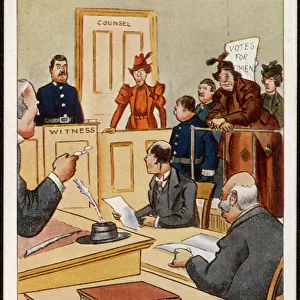
Home > Arts > Artists > T > John Tallis
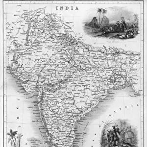
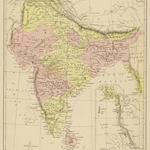
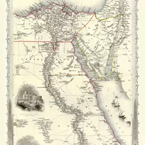
Malay Archipelago, or East India Islands 1851

![]()
Wall Art and Photo Gifts from MapSeeker
Malay Archipelago, or East India Islands 1851
A fine facimile artworked from an antique original map of the Malay Archipelago, or East India Islands, issued as part of the 1851 edition of John Tallis and Companys " The Illustrated Atlas and Modern History of the World"
Welcome to the Mapseeker Image library and enter an historic gateway to one of the largest on-line collections of Historic Maps, Nostalgic Views, Vista's and Panorama's from a World gone by.
Media ID 20347670
© Mapseeker Publishing Ltd
John Tallis John Tallis Map Tallis Map
FEATURES IN THESE COLLECTIONS
> Arts
> Artists
> T
> John Tallis
> Asia
> India
> Related Images
> Maps and Charts
> India
> Maps and Charts
> Related Images
> Maps and Charts
> World
> MapSeeker
> Maps of Asia and Middle East
> Maps of the Middle East and East Indies
EDITORS COMMENTS
This print showcases a remarkable piece of cartographic history - an antique original map of the Malay Archipelago, or East India Islands, dating back to 1851. Painstakingly reproduced as a fine facsimile artwork, this map is a testament to the skill and precision of its creator, John Tallis. Part of the esteemed 1851 edition of "The Illustrated Atlas and Modern History of the World" by John Tallis and Company, this map offers a glimpse into the intricate details and rich cultural tapestry that defined these enchanting islands during that era. The old-world charm emanating from this print transports viewers back in time to an age when exploration was rife and mysteries awaited discovery. John Rapkin's contribution to this masterpiece cannot be overlooked either. His artistic touch adds depth and vibrancy to every corner of the archipelago depicted on the map. From lush forests teeming with wildlife to bustling ports dotted along coastlines, his illustrations breathe life into each island captured within these borders. Whether you are an avid collector or simply appreciate historical artifacts, this print is sure to captivate your imagination. It serves as both a visual delight for admirers of vintage maps and a valuable resource for scholars seeking insights into past civilizations
MADE IN THE USA
Safe Shipping with 30 Day Money Back Guarantee
FREE PERSONALISATION*
We are proud to offer a range of customisation features including Personalised Captions, Color Filters and Picture Zoom Tools
SECURE PAYMENTS
We happily accept a wide range of payment options so you can pay for the things you need in the way that is most convenient for you
* Options may vary by product and licensing agreement. Zoomed Pictures can be adjusted in the Cart.