Home > Maps and Charts > Abraham Ortelius
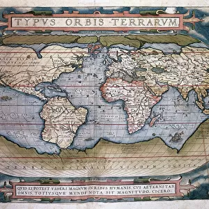
Civitatis Orbis Terrarum. Wismar

![]()
Wall Art and Photo Gifts from Mary Evans Picture Library
Civitatis Orbis Terrarum. Wismar
BRAUN, George (1541-1622). Civitatis Orbis Terrarum (Theatrum orbis terrarum). 1572-1617. Wismar (1572). Left upper detail. Volume I. Etching. SPAIN. CASTILE AND LEON. Salamanca. Salamanca University Library
Mary Evans Picture Library makes available wonderful images created for people to enjoy over the centuries
Media ID 14179716
© P. Rotger/Iberfoto/Mary Evans
1527 1535 1541 1572 1590 1598 1617 1622 Abraham Braun Castile Cities Civitatis Commerce Commerces Commercial Craft Crafts Daylight Engravings Etching Etchings Franz Hogenberg Landscapes Leon Orbis Ortelius Salamanca Sunlight Terrarum Theatrum University Ostsee Upper Volume Wismar
EDITORS COMMENTS
This detail from the historic map "Civitatis Orbis Terrarum" (Theatrum orbis terrarum), created by George Braun and Abraham Ortelius in collaboration with Franz Hogenberg between 1572 and 1617, offers a glimpse into the bustling port city of Wismar, located in the Duchy of Mecklenburg-Western Pomerania, Germany, along the Baltic Sea. The map is considered one of the most influential and accurate world maps of its time. The image showcases the left upper portion of the map, with Volume I of the atlas displayed in horizontal format. The map is etched in intricate detail, revealing the city of Wismar nestled along the shores of the Ostsee (Baltic Sea). Boats and ships of various sizes can be seen anchored in the harbor, indicating the city's significant role in maritime commerce during the late 16th century. The map's vibrant colors and detailed engravings are brought to life under daylight, casting a warm glow over the urban landscape. Salamanca University Library in Spain houses this precious piece of cartographic history. This map was produced during a time when European exploration and discovery were at their height, and the intricate details of this map reflect the world's growing knowledge and understanding of geography. It is important to note that this map should not be confused with the commercial enterprise, Civitatis Orbis Terrarum, a modern-day mapping and travel planning company. Instead, it is a remarkable historical document, showcasing the intricacies of cartography during the Renaissance era.
MADE IN THE USA
Safe Shipping with 30 Day Money Back Guarantee
FREE PERSONALISATION*
We are proud to offer a range of customisation features including Personalised Captions, Color Filters and Picture Zoom Tools
SECURE PAYMENTS
We happily accept a wide range of payment options so you can pay for the things you need in the way that is most convenient for you
* Options may vary by product and licensing agreement. Zoomed Pictures can be adjusted in the Cart.