Home > Arts > Artists > W > Robert Walker
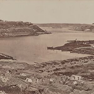
Map showing the Siege of Sevastopol, Crimean War, 1854-1855, (1893). Artist: Robert Walker
. Artist: Robert Walker")
![]()
Wall Art and Photo Gifts from Heritage Images
Map showing the Siege of Sevastopol, Crimean War, 1854-1855, (1893). Artist: Robert Walker
Map showing the Siege of Sevastopol, Crimean War, 1854-1855, (1893). The Siege of Sevastopol, lasted from September 1854 until September 1855. In September 1854, Allied troops (United Kingdom, French and Sardinian) landed in the Crimea and besieged the city of Sevastopol, home of the Tsars Black Sea fleet which threatened the Mediterranean. An engraving from James Taylors The Age We Live In: A History of the Nineteenth Century, From the Peace of 1815 to the Present Time, William Mackenzie, (London, 1893)
Heritage Images features heritage image collections
Media ID 14906150
© The Print Collector / Heritage-Images
Black Sea Campaign Cartography Crimean War 1853 1856 Krym Map Making Robert Walker Sebastopol Sevastopol Siege Siege Of Sebastopol Ukraine Walker Print Collector2
FEATURES IN THESE COLLECTIONS
> Arts
> Artists
> H
> Robert Home
> Arts
> Artists
> J
> William James
> Arts
> Artists
> R
> James Roberts
> Arts
> Artists
> Related Images
> Arts
> Artists
> W
> James Walker
> Arts
> Artists
> W
> Robert Walker
EDITORS COMMENTS
This print showcases a detailed map depicting the Siege of Sevastopol during the Crimean War, which took place from 1854 to 1855. Created by artist Robert Walker in 1893, this historical artwork offers a glimpse into one of the most significant military campaigns of the 19th century. The siege commenced when Allied forces comprising troops from the United Kingdom, France, and Sardinia landed in Crimea and laid siege to Sevastopol. The city was home to Tsar's Black Sea fleet, posing a threat to Mediterranean security. Lasting for an entire year until September 1855, this intense conflict witnessed numerous battles and strategic maneuvers. James Taylor's engraving titled "The Age We Live In: A History of the Nineteenth Century" features this remarkable map as part of its comprehensive narrative on world events during that era. It was published by William Mackenzie in London in 1893. With vibrant colors and intricate cartography, this print not only serves as a valuable resource for historians but also captures viewers' attention with its artistic beauty. It highlights key geographical features such as the Black Sea while emphasizing Sevastopol's significance within the region. As we explore this image further, it becomes evident that Robert Walker masterfully combines history and artistry to present us with an invaluable visual representation of a critical moment in time – reminding us once again why maps are not just tools for navigation but also windows into our past.
MADE IN THE USA
Safe Shipping with 30 Day Money Back Guarantee
FREE PERSONALISATION*
We are proud to offer a range of customisation features including Personalised Captions, Color Filters and Picture Zoom Tools
SECURE PAYMENTS
We happily accept a wide range of payment options so you can pay for the things you need in the way that is most convenient for you
* Options may vary by product and licensing agreement. Zoomed Pictures can be adjusted in the Cart.