Home > Europe > Portugal > Maps
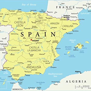
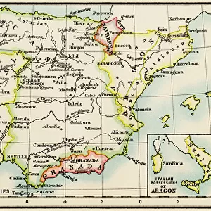
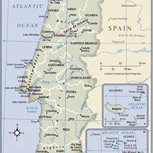
Map - Spain and Portugal, 1807-1814

![]()
Wall Art and Photo Gifts from Mary Evans Picture Library
Map - Spain and Portugal, 1807-1814
Spain and Portugal, 1807-1814. From a collection of maps relevant to campaigns between 1794-1815. From the collection of the former Buffs Regimental Museum. Associated with Wars of the French Revolution (1793-1802) and Napoleonic Wars (1803-1815). Date: 1814
Mary Evans Picture Library makes available wonderful images created for people to enjoy over the centuries
Media ID 14403878
© The National Army Museum / Mary Evans Picture Library
1793 1794 1802 1803 1807 1814 1815 Associated Buffs Campaigns Maps Napoleonic Peninsular Portugal Regimental Revolution Southern Wars
FEATURES IN THESE COLLECTIONS
> Europe
> Portugal
> Related Images
> Europe
> Spain
> Related Images
EDITORS COMMENTS
This intricately detailed map depicts Spain and Portugal during the tumultuous years of 1807-1814. During this period, the Peninsular War raged between the French forces led by Napoleon Bonaparte and the allied forces of Spain, Portugal, and the United Kingdom. The map is part of a larger collection of maps relevant to the campaigns between 1794 and 1815, a time marked by the French Revolution and the subsequent Napoleonic Wars. The map provides a comprehensive view of the Iberian Peninsula during this pivotal moment in history. The borders of Spain and Portugal are clearly marked, as are major cities, rivers, and mountain ranges. The map also highlights key military installations and strategic locations, offering insight into the military tactics and maneuvers that took place during this time. The map is from the collection of the former Buffs Regimental Museum, which holds a vast array of historical artifacts and documents related to the military history of the British Army. The Buffs, or the East Kent Regiment, played a significant role in the Peninsular War, making this map a valuable addition to the museum's holdings. The Peninsular War, also known as the Peninsular Campaign, was a turning point in the Napoleonic Wars, as it marked the first major defeat for the French forces on European soil. The war ended in 1814, with the signing of the Treaty of Vienna, which restored the Bourbon monarchy in France and redrew the map of Europe. This map offers a unique glimpse into the political and military landscape of the Iberian Peninsula during this time of upheaval and change.
MADE IN THE USA
Safe Shipping with 30 Day Money Back Guarantee
FREE PERSONALISATION*
We are proud to offer a range of customisation features including Personalised Captions, Color Filters and Picture Zoom Tools
SECURE PAYMENTS
We happily accept a wide range of payment options so you can pay for the things you need in the way that is most convenient for you
* Options may vary by product and licensing agreement. Zoomed Pictures can be adjusted in the Cart.