Home > Europe > Russia > Maps
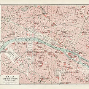
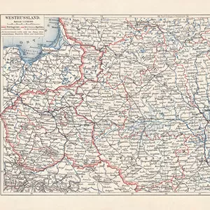
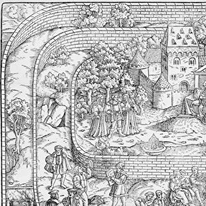
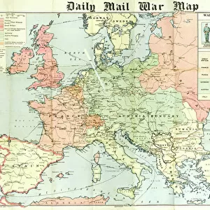
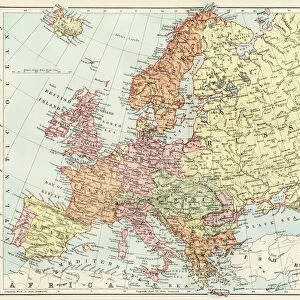
Two rival designs for the Map of Europe, WW1

![]()
Wall Art and Photo Gifts from Mary Evans Picture Library
Two rival designs for the Map of Europe, WW1
Two rival designs for the Map of Europe at the start of the First World War. Above: a new map as probably already designed by the Hohenzollern map specialist in Berlin, in which Germany has a vastly expanded territory. Below: an alternative design in which Russia is expanded westwards and a small German region named Ultimania is left. Date: August 1914
Mary Evans Picture Library makes available wonderful images created for people to enjoy over the centuries
Media ID 14121978
© Illustrated London News Ltd/Mary Evans
Alternative Berlin Expanded Expansion Hohenzollern Imaginary Maps Region Rival Territory
FEATURES IN THESE COLLECTIONS
> Europe
> Related Images
> Europe
> Russia
> Related Images
> Maps and Charts
> Early Maps
> Maps and Charts
> Related Images
> Maps and Charts
> World
EDITORS COMMENTS
At the onset of the First World War in August 1914, the map of Europe was poised for significant change. Above the fold in this imaginary print, a new map design, likely drafted by the Hohenzollern map specialists in Berlin, showcases a vastly expanded German territory. The map reflects the ambitious territorial ambitions of the German Empire, with new borders extending far beyond its existing boundaries. Below the fold, an alternative map design challenges the German expansionist agenda. In this vision, Russia is expanded westwards, absorbing territories that were once part of the Austro-Hungarian and Ottoman empires. A small German region named Ultimania, located in the easternmost part of Europe, is left untouched in this design. These two rival map designs represent the contrasting geopolitical aspirations of the major European powers at the start of the Great War. The Hohenzollern map reflects the aggressive expansionist policies of the German Empire, while the alternative design envisions a more balanced European landscape with a stronger Russia. The First World War marked a turning point in European history, leading to the redrawing of borders and the reshaping of political alliances. These maps serve as a reminder of the complex geopolitical landscape that existed before the war and the far-reaching consequences of the conflict. This print is an imaginary representation of the maps that could have been, offering a glimpse into the alternative histories that might have unfolded had the course of events been different. It is essential to remember that these maps are not historical documents but rather an exploration of the possibilities that existed at the beginning of the First World War.
MADE IN THE USA
Safe Shipping with 30 Day Money Back Guarantee
FREE PERSONALISATION*
We are proud to offer a range of customisation features including Personalised Captions, Color Filters and Picture Zoom Tools
SECURE PAYMENTS
We happily accept a wide range of payment options so you can pay for the things you need in the way that is most convenient for you
* Options may vary by product and licensing agreement. Zoomed Pictures can be adjusted in the Cart.