Home > Arts > Photorealistic artworks > Detailed art pieces > Masterful detailing in art
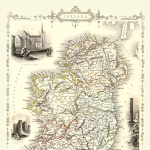
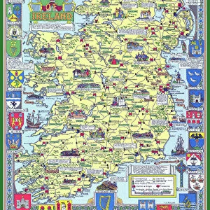
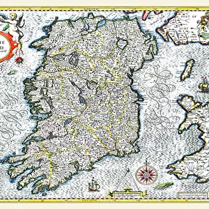
Old Map of Ireland 1852 by Henry George Collins

![]()
Wall Art and Photo Gifts from MapSeeker
Old Map of Ireland 1852 by Henry George Collins
This is a finely detailed map of Ireland remastered from a rare Atlas of the World published in 1852 by Henry George Collins. Although these Henry Collins produced maps of the highest quality in his time unfortunately not the same could be said in terms of his business success. His maps were later obtained by the famous Stanford Map Company and used in their publications
Welcome to the Mapseeker Image library and enter an historic gateway to one of the largest on-line collections of Historic Maps, Nostalgic Views, Vista's and Panorama's from a World gone by.
Media ID 20347283
© Mapseeker Publishing Ltd
Collins Collins Atlas Collins Atlas Map Collins Map
FEATURES IN THESE COLLECTIONS
> Arts
> Photorealistic artworks
> Detailed art pieces
> Masterful detailing in art
> Europe
> Republic of Ireland
> Maps
> Maps and Charts
> Popular Maps
> Maps and Charts
> Related Images
> Maps and Charts
> World
> MapSeeker
> Maps from the British Isles
> Ireland and Provinces PORTFOLIO
EDITORS COMMENTS
This beautifully preserved print showcases the "Old Map of Ireland 1852" by Henry George Collins, a renowned cartographer of his time. Remastered from a rare Atlas of the World published in 1852, this map provides an intricate and detailed depiction of Ireland during that era. Henry George Collins was widely recognized for producing maps of exceptional quality, as evident in this remarkable piece. However, despite his talent and dedication to his craft, he faced challenges when it came to achieving business success. Nevertheless, his maps found their way into the hands of the prestigious Stanford Map Company, who recognized their value and incorporated them into their own publications. The historical significance of this map cannot be understated. It offers us a glimpse into Ireland's past - its cities, towns, rivers, mountains - all meticulously documented with precision and care. This old Irish map serves as a testament to both Collins' expertise as a cartographer and the enduring allure of vintage cartography. Whether you are an avid history enthusiast or simply appreciate fine artistry in mapping, this print is sure to captivate your imagination. Transport yourself back to 1852 and explore the intricacies of Ireland through Henry George Collins' masterful creation – an invaluable addition to any collection celebrating our rich cultural heritage.
MADE IN THE USA
Safe Shipping with 30 Day Money Back Guarantee
FREE PERSONALISATION*
We are proud to offer a range of customisation features including Personalised Captions, Color Filters and Picture Zoom Tools
SECURE PAYMENTS
We happily accept a wide range of payment options so you can pay for the things you need in the way that is most convenient for you
* Options may vary by product and licensing agreement. Zoomed Pictures can be adjusted in the Cart.