Home > Europe > United Kingdom > England > Sussex > Old Town
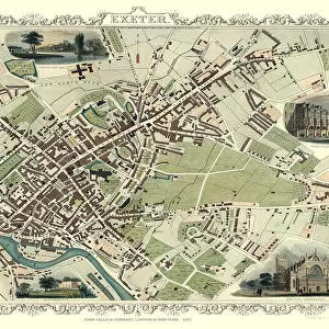
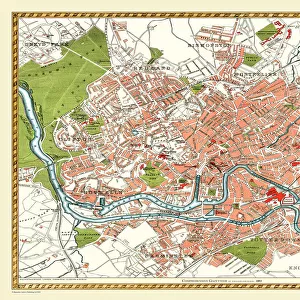
Old Map of Brighton 1851 by John Tallis

![]()
Wall Art and Photo Gifts from MapSeeker
Old Map of Brighton 1851 by John Tallis
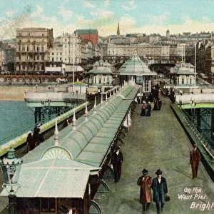
A most attractive Victorian plan of Brighton in Sussex by John Tallis 1851 showing its famous Chain Pier reaching out into the English Channel.. At the bottom of the plan there is a splendid view towards the Chain Pier showing Victorian people enjoying strolls along the sea front. The second illustration is of the Old Steyne and Pavilion, the third is of Brighton Railway
Welcome to the Mapseeker Image library and enter an historic gateway to one of the largest on-line collections of Historic Maps, Nostalgic Views, Vista's and Panorama's from a World gone by.
Media ID 20347725
Historic Map John Tallis John Tallis Map Old Town Plan Tallis Map Brighton
FEATURES IN THESE COLLECTIONS
> Arts
> Artists
> T
> John Tallis
> Europe
> United Kingdom
> England
> Sussex
> Brighton
> Europe
> United Kingdom
> England
> Sussex
> Old Town
> Europe
> United Kingdom
> England
> Sussex
> Related Images
> Maps and Charts
> Related Images
> MapSeeker
> British Town And City Plans
> English & Welsh PORTFOLIO
> Popular Themes
> Railway Posters
EDITORS COMMENTS
This print showcases an exquisite piece of history - the "Old Map of Brighton 1851" by John Tallis. This Victorian plan offers a delightful glimpse into the charming town of Brighton in Sussex during its heyday. The focal point is undoubtedly the iconic Chain Pier, gracefully extending out into the vast expanse of the English Channel. As we explore this remarkable map, our eyes are drawn to a splendid view at the bottom, revealing Victorian-era individuals relishing leisurely strolls along the enchanting seafront. Their presence adds life and character to this snapshot from yesteryears. The second illustration within this treasure trove takes us to another beloved landmark - the Old Steyne and Pavilion. Here, we can envision grand gatherings and elegant affairs that once graced these hallowed grounds. Lastly, but certainly not least, we encounter a depiction of Brighton Railway on this historic map. A testament to progress and connectivity during that era, it serves as a reminder of how transportation has shaped cities throughout time. John Tallis's meticulous craftsmanship shines through every intricate detail presented in this city plan. It allows us to immerse ourselves in Brighton's rich heritage while marveling at its evolution over centuries. This print is more than just an old map; it is a gateway into nostalgia and wonderment for those who appreciate historical beauty.
MADE IN THE USA
Safe Shipping with 30 Day Money Back Guarantee
FREE PERSONALISATION*
We are proud to offer a range of customisation features including Personalised Captions, Color Filters and Picture Zoom Tools
SECURE PAYMENTS
We happily accept a wide range of payment options so you can pay for the things you need in the way that is most convenient for you
* Options may vary by product and licensing agreement. Zoomed Pictures can be adjusted in the Cart.