Home > Arts > Contemporary art > Landscapes > Desert landscapes
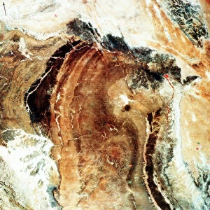
Death Valley, California, USA, 1982-1993

![]()
Wall Art and Photo Gifts from Heritage Images
Death Valley, California, USA, 1982-1993
Death Valley, California, USA, 1982-1993. First full scene from the Thematic Mapper on Landsat 4. The vegetation-sparse terrain is dominated by landforms and other geological features: most major landmarks are physiographic. False colour scene shows most ranges and alluvial valleys largely barren of vegetation.True colour version reveals details of rock types and structures. Variations in colour tone in ranges relate to different stratigraphic units
Heritage Images features heritage image collections
Media ID 14863935
© NASA/Oxford Science Archive / Heritage-Images
1980s 1990s California Cartography Desert Eighties Geology Map Making Nasa Nineties Oxford Science Archive Satellite Satellite Photography Valley Wilderness Death Valley Landsat
FEATURES IN THESE COLLECTIONS
> Animals
> Mammals
> Cricetidae
> California Mouse
> Animals
> Mammals
> Muridae
> Desert Mouse
> Arts
> Contemporary art
> Landscapes
> Desert landscapes
> Arts
> Contemporary art
> Landscapes
> Mountain landscapes
> Arts
> Contemporary art
> Photography
> Landscape photography
> Arts
> Landscape paintings
> Landscape art
> Mountain landscapes
> Historic
> Monuments and landmarks
> Iconic structures
> Maps and Charts
> Geological Map
> Maps and Charts
> Related Images
EDITORS COMMENTS
This print captures the stark beauty of Death Valley, California, USA, between 1982 and 1993. Taken by the Thematic Mapper on Landsat 4, it provides a comprehensive view of this iconic desert landscape. The image showcases the dominance of landforms and geological features in an area where vegetation is sparse. In false color, we witness vast stretches of barren land with most ranges and alluvial valleys devoid of any greenery. This representation allows us to appreciate the physiographic landmarks that define Death Valley's unique character. However, when viewed in true color, intricate details of rock types and structures emerge from the scene. The variations in color tone across the ranges correspond to different stratigraphic units found within this geological wonderland. It is through images like these that scientists can study and understand Earth's diverse landscapes more comprehensively. As we gaze upon this photograph, we are reminded of Death Valley's reputation as one of America's hottest and driest locations. Its untamed wilderness evokes a sense of awe while highlighting its significance for geographical research conducted by organizations such as NASA. This print serves as a testament to humanity's ability to capture our planet's natural wonders from space using satellite photography technology developed during the late twentieth century. It stands as both a scientific achievement and a stunning work of art that invites us to explore the depths and intricacies hidden within our world’s landscapes.
MADE IN THE USA
Safe Shipping with 30 Day Money Back Guarantee
FREE PERSONALISATION*
We are proud to offer a range of customisation features including Personalised Captions, Color Filters and Picture Zoom Tools
SECURE PAYMENTS
We happily accept a wide range of payment options so you can pay for the things you need in the way that is most convenient for you
* Options may vary by product and licensing agreement. Zoomed Pictures can be adjusted in the Cart.