Home > Africa > Democratic Republic of the Congo > Lakes > Related Images
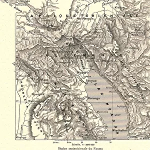
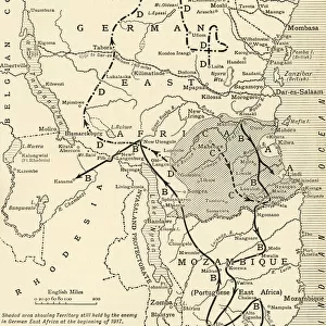
Map illustrating the Closing Phases of the East African Campaign, 1917-18, (c1920)
")
![]()
Wall Art and Photo Gifts from Heritage Images
Map illustrating the Closing Phases of the East African Campaign, 1917-18, (c1920)
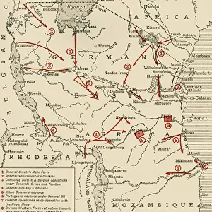
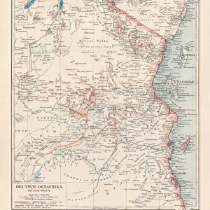
Map illustrating the Closing Phases of the East African Campaign, 1917-18, (c1920). European powers in Africa during the First World War: Shaded area showing Territory still held by the enemy in German East Africa at the beginning of 1917; Coastal areas held by British troops; General von Lettow-Vorbecks track from December 1916 to his surrender on November 14, 1918; Colonel Tafels line of retreat from the Mohenge district until his surrender on November 27, 1918; Track of the Wintgens-Naumann raiding force, February-October 1917. From " The Great World War: A History", Volume IX, edited by Frank A Mumby. [The Gresham Publishing Company Ltd, London, c1920]
Heritage Images features heritage image collections
Media ID 19666065
© The Print Collector/Heritage Images
Belgian Congo British East Africa Coastline Colonies Colony Congo East Africa East African Campaign Frank A Frank A Mumby Frank Arthur Frank Arthur Mumby Front Line Frontline German East Africa German East African Campaign Gresham Publishing Co Ltd Gresham Publishing Company Imperialism Indian Ocean Keystone Archives Lines Mozambique Mumby Mumby Frank A Mumby Frank Arthur Nyasaland Position Positions Rhodesia Rhodesia Africa The Great World War A History Theatre Of War Battlefield Lake Malawi Lake Nyasa
FEATURES IN THESE COLLECTIONS
> Africa
> Democratic Republic of the Congo
> Lakes
> Related Images
> Africa
> Malawi
> Lakes
> Lake Nyasa
> Africa
> Malawi
> Lakes
> Related Images
> Africa
> Malawi
> Related Images
> Africa
> Mozambique
> Lakes
> Lake Nyasa
> Africa
> Mozambique
> Lakes
> Related Images
> Africa
> Mozambique
> Maps
> Africa
> Mozambique
> Related Images
> Africa
> Republic of the Congo
> Lakes
> Related Images
EDITORS COMMENTS
This print showcases a detailed map illustrating the closing phases of the East African Campaign during 1917-18. The map, taken from "The Great World War: A History" provides a comprehensive overview of the European powers' presence in Africa during World War I. It highlights various significant locations and tracks related to this campaign. The shaded area represents the territory still held by the enemy in German East Africa at the beginning of 1917, while coastal areas are shown as being under British control. The map also traces General von Lettow-Vorbeck's track from December 1916 until his surrender on November 14,1918. Additionally, it depicts Colonel Tafel's line of retreat from the Mohenge district until his surrender on November 27,1918. Another notable feature is the track of the Wintgens-Naumann raiding force between February and October 1917. This image offers insights into key military movements and positions during this period. With its historical significance, this print serves as a valuable resource for understanding colonialism, imperialism, and warfare in early twentieth-century Africa. It sheds light on how European powers vied for control over territories such as German East Africa (present-day Tanzania) and their impact on local populations. Preserved by Heritage Images, this photograph captures an important chapter in world history that shaped not only Africa but also global geopolitics during that time.
MADE IN THE USA
Safe Shipping with 30 Day Money Back Guarantee
FREE PERSONALISATION*
We are proud to offer a range of customisation features including Personalised Captions, Color Filters and Picture Zoom Tools
SECURE PAYMENTS
We happily accept a wide range of payment options so you can pay for the things you need in the way that is most convenient for you
* Options may vary by product and licensing agreement. Zoomed Pictures can be adjusted in the Cart.