Home > Arts > Artists > O > Abraham Ortelius
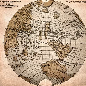
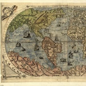
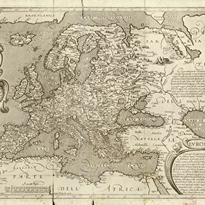
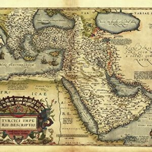
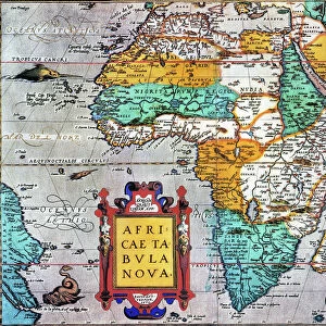
1570, Ortelius Map of Asia, first edition, Abraham Ortelius, also Orthellius, 1527 - 1598

![]()
Wall Art and Photo Gifts from Liszt Collection
1570, Ortelius Map of Asia, first edition, Abraham Ortelius, also Orthellius, 1527 - 1598
1570, Ortelius Map of Asia, first edition, Abraham Ortelius, also Orthellius, 1527 - 1598, Flemish, Netherlandish cartographer and geographer
Liszt Collection of nineteenth-century engravings and images to browse and enjoy
Media ID 14004426
© Artokoloro Quint Lox Limited
1527 1598 1570 Abraham Ortelius First Edition Flemish 1527 – 1598 Also Orthellius Antique Map Latitude Longitude Mappa Mundi Old Antique Plan Old Antique View Ols Antique Map Rare Old Maps Topo
FEATURES IN THESE COLLECTIONS
> Arts
> Artists
> O
> Abraham Ortelius
> Europe
> France
> Canton
> Landes
> Historic
> Space exploration
> Maps and Charts
> Abraham Ortelius
> Maps and Charts
> Early Maps
> Maps and Charts
> Related Images
> Maps and Charts
> World
EDITORS COMMENTS
This print showcases the first edition of the 1570 Ortelius Map of Asia, created by Abraham Ortelius, a renowned Flemish and Netherlandish cartographer and geographer. Known for his exceptional attention to detail, Ortelius meticulously crafted this map to provide an accurate representation of the Asian continent during that time period. The map's topography, cartography, and geography are beautifully illustrated on paper with intricate details. It serves as a testament to the ancient art of mapping and navigation. The vintage aesthetic adds a touch of nostalgia, taking us back in time to explore the world through historical eyes. As we gaze upon this decorative piece, we can't help but appreciate its historical significance. This rare old map offers insights into how people perceived Asia centuries ago – their understanding of its regions, space exploration, and geographical features. With its grid lines depicting latitude and longitude in a geometric fashion, this antique map invites us on a journey of discovery. It reminds us that even in our modern age where technology has revolutionized navigation systems, there is still value in appreciating the craftsmanship behind these historic maps. Whether you're an avid collector or simply fascinated by history and exploration, this remarkable print captures the essence of an era when maps were not just tools but works of art themselves – windows into our past and gateways to new horizons.
MADE IN THE USA
Safe Shipping with 30 Day Money Back Guarantee
FREE PERSONALISATION*
We are proud to offer a range of customisation features including Personalised Captions, Color Filters and Picture Zoom Tools
SECURE PAYMENTS
We happily accept a wide range of payment options so you can pay for the things you need in the way that is most convenient for you
* Options may vary by product and licensing agreement. Zoomed Pictures can be adjusted in the Cart.