Home > Arts > Artists > Albrecht Durer > Woodcuts
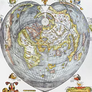
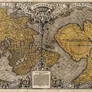
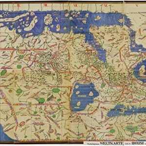
Durers world map, 1515

![]()
Wall Art and Photo Gifts from Science Photo Library
Durers world map, 1515
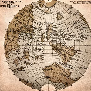
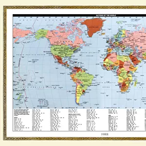
Durers world map, 1515. Albrecht Durer (1471- 1528) was a German artist. His skillful use of perspective and mathematical proportions made him one of the outstanding artistic figures of the early 16th century. This world map is based on Ptolemys map plus extensions from Behaims Globe of 1492. It is the first known perspective drawing of the entire Earth as a sphere, and was published in 1515, using the best maps of the time in collaboration with Nuremberg astronomer Johann Stabius. The map shows the world surrounded by 12 wind gods. Taken from Dr Willi Kurths The Complete Woodcuts of Albrecht Durer (1936)
Science Photo Library features Science and Medical images including photos and illustrations
Media ID 6351281
© SHEILA TERRY/SCIENCE PHOTO LIBRARY
1500s 1515 16th Century Albrecht Durer Ancient Atlas Cartography Discovery Dr Willi Kurth Earth Science Exploration Globe Journey Knowledge Mapping Maps Renaissance Sciences Sphere Travel Wood Cut
FEATURES IN THESE COLLECTIONS
> Arts
> Art Movements
> Renaissance Art
> Arts
> Artists
> Albrecht Durer
> Fine art prints
> Arts
> Artists
> Albrecht Durer
> Renaissance art
> Arts
> Artists
> Albrecht Durer
> Woodcuts
> Arts
> Artists
> Albrecht Durer
> Arts
> Artists
> D
> Albrecht Durer
> Arts
> Artists
> Related Images
> Europe
> Germany
> Nuremberg
> Maps and Charts
> Popular Maps
> Popular Themes
> Albrecht Durer
> Science Photo Library
> Top Picks
EDITORS COMMENTS
This print showcases Albrecht Durer's world map from 1515, a remarkable piece of art and cartography. Durer, a renowned German artist of the early 16th century, was celebrated for his mastery of perspective and mathematical proportions. In collaboration with Nuremberg astronomer Johann Stabius, he created this groundbreaking map by combining Ptolemy's original map with additions from Behaim's Globe of 1492. What makes this world map truly exceptional is that it represents the first known perspective drawing of the entire Earth as a sphere. Published in 1515, it utilized the best maps available at that time to provide an accurate depiction of our planet. Surrounding the globe are twelve wind gods, adding an artistic touch to this historical masterpiece. Through this image captured from Dr Willi Kurth's comprehensive collection "The Complete Woodcuts of Albrecht Durer" (1936), we delve into a journey back in time - exploring not only geographical knowledge but also gaining insight into the Renaissance era. This artwork symbolizes discovery and exploration during the 16th century when humanity thirsted for understanding and sought to expand its horizons. With elements like ancient history, earth science, and cartography intertwined within its intricate details, Durer's world map remains an invaluable artifact representing human curiosity and intellectual progress. As we gaze upon this woodcut print courtesy of Science Photo Library, we are reminded once again how art can beautifully merge with scientific endeavors to
MADE IN THE USA
Safe Shipping with 30 Day Money Back Guarantee
FREE PERSONALISATION*
We are proud to offer a range of customisation features including Personalised Captions, Color Filters and Picture Zoom Tools
SECURE PAYMENTS
We happily accept a wide range of payment options so you can pay for the things you need in the way that is most convenient for you
* Options may vary by product and licensing agreement. Zoomed Pictures can be adjusted in the Cart.