Home > Aerial Photography > Related Images
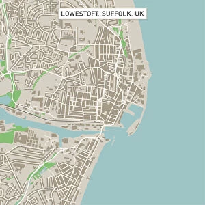
Westminster Colorado US City Street Map

![]()
Wall Art and Photo Gifts from Fine Art Storehouse
Westminster Colorado US City Street Map
Vector Illustration of a City Street Map of Westminster, Colorado, USA. Scale 1:60, 000.
All source data is in the public domain.
U.S. Geological Survey, US Topo
Used Layers:
USGS The National Map: National Hydrography Dataset (NHD)
USGS The National Map: National Transportation Dataset (NTD)
Unleash your creativity and transform your space into a visual masterpiece!
Frank Ramspott
Media ID 15215830
© Frank Ramspott, all rights reserved
Aerial View City Map Colorado Computer Graphic Directly Above Downtown District Gray Road Map Text Westminster Digitally Generated Image Green Color White Color
FEATURES IN THESE COLLECTIONS
> Aerial Photography
> Related Images
> Animals
> Insects
> Hemiptera
> Green Scale
> Arts
> Contemporary art
> Digital artwork
> Street art
> Arts
> Landscape paintings
> Waterfall and river artworks
> River artworks
> Arts
> Portraits
> Pop art gallery
> Street art portraits
> Arts
> Street art graffiti
> Digital art
> Digital paintings
> Arts
> Street art graffiti
> Digital art
> Vector illustrations
> Fine Art Storehouse
> Map
> Street Maps
> Fine Art Storehouse
> Map
> USA Maps
> Maps and Charts
> Geological Map
> Maps and Charts
> Related Images
> North America
> United States of America
> Colorado
> Related Images
EDITORS COMMENTS
This print showcases a meticulously detailed city street map of Westminster, Colorado, USA. With a scale of 1:60,000, every intricate feature is brought to life in this vector illustration. The artist, Frank Ramspott, has skillfully utilized various layers from the public domain source data including USGS The National Map: National Hydrography Dataset (NHD) and USGS The National Map: National Transportation Dataset (NTD). The image captures the essence of Westminster's downtown district with its bustling streets and vibrant atmosphere. A serene lake and river gracefully flow through the cityscape, adding to its natural beauty. Roads crisscross throughout the map providing easy navigation for residents and visitors alike. Ramspott's design expertise shines through in this digitally generated artwork that offers an aerial view directly above Westminster. Shades of gray, blue, white, and green create a visually appealing color palette that complements both the physical geography and computer graphic elements. With no people present in the image itself, attention is solely focused on appreciating the artistry behind this stunning piece. Whether you are a cartography enthusiast or simply admire beautiful maps as decorative pieces, this print will undoubtedly add sophistication to any space it graces
MADE IN THE USA
Safe Shipping with 30 Day Money Back Guarantee
FREE PERSONALISATION*
We are proud to offer a range of customisation features including Personalised Captions, Color Filters and Picture Zoom Tools
SECURE PAYMENTS
We happily accept a wide range of payment options so you can pay for the things you need in the way that is most convenient for you
* Options may vary by product and licensing agreement. Zoomed Pictures can be adjusted in the Cart.