Home > Arts > Street art graffiti > Digital art > Vector illustrations
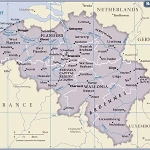
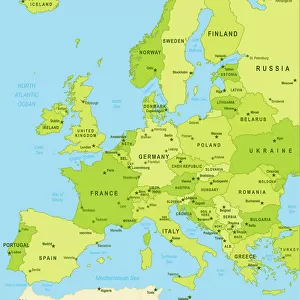
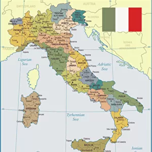
Belgium Vector Map

![]()
Wall Art and Photo Gifts from Fine Art Storehouse
Belgium Vector Map
Highly detailed vector map of Belgium. File was created on July 14, 2011. The colors in the.eps-file are ready for print (CMYK). Included files: EPS (v8) and Hi-Res JPG
Unleash your creativity and transform your space into a visual masterpiece!
Frank Ramspott
Media ID 14833519
© Frank Ramspott, all rights reserved
Antwerp Atlantic Ocean Belgium Benelux Bruges Brussels Clip Art Computer Graphic Country Geographic Area Geology Green Hainaut Latitude Longitude Luxembourg North Sea Region Satellite View Square Vector View Into Land Wallonia West Flanders Ardennes Digitally Generated Image Ghent Leuven Liege Limburg Mechelen Meuse Oost Vlaanderen Scheldt River Vlaams Brabant
FEATURES IN THESE COLLECTIONS
> Arts
> Artists
> O
> Oceanic Oceanic
> Arts
> Landscape paintings
> Waterfall and river artworks
> River artworks
> Arts
> Photorealistic artworks
> Detailed art pieces
> Masterful detailing in art
> Arts
> Street art graffiti
> Digital art
> Digital paintings
> Arts
> Street art graffiti
> Digital art
> Vector illustrations
> Fine Art Storehouse
> Map
> Map Illustrations
EDITORS COMMENTS
This highly detailed vector map of Belgium, created on July 14,2011, is a stunning piece of cartography. The colors in the EPS file are specifically designed for print (CMYK), ensuring vibrant and accurate representations of this beautiful country. Included in this package are both an EPS (v8) file and a high-resolution JPG image. The map showcases various regions and landmarks that make Belgium so unique. From the bustling cityscape of Brussels to the picturesque views of Bruges, every corner of this diverse nation is captured with precision. The satellite view allows us to appreciate its geographic area, bordered by Luxembourg and France. As we explore further into the map, we encounter notable cities like Antwerp and Ghent, each contributing their own charm to Belgium's cultural tapestry. The North Sea coastline stretches along West Flanders while inland areas such as Wallonia boast breathtaking landscapes like the Ardennes region. With no people visible in this digitally generated image by Frank Ramspott, our focus remains solely on appreciating Belgium's natural beauty and architectural wonders. The Scheldt River meanders through the land while the Meuse adds another touch of serenity to its landscape. Whether you're a travel enthusiast or simply fascinated by maps, this artwork offers an opportunity to immerse yourself in Belgium's rich history and captivating geography. Its square shape makes it ideal for framing or incorporating into creative projects. With vivid blues representing water bodies and lush greens depicting land areas, this computer-generated illustration truly
MADE IN THE USA
Safe Shipping with 30 Day Money Back Guarantee
FREE PERSONALISATION*
We are proud to offer a range of customisation features including Personalised Captions, Color Filters and Picture Zoom Tools
SECURE PAYMENTS
We happily accept a wide range of payment options so you can pay for the things you need in the way that is most convenient for you
* Options may vary by product and licensing agreement. Zoomed Pictures can be adjusted in the Cart.