Home > Animals > Birds > Gruiformes > Rallidae > King Rail
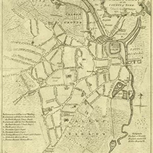
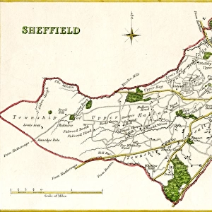
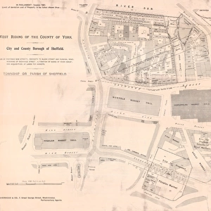
Plan of part of the Town of Sheffield shewing the existing markets, the property of His Grace the Duke of Norfolk, and the Projected improvements, 1847

![]()
Wall Art and Photo Gifts from Sheffield City Archives
Plan of part of the Town of Sheffield shewing the existing markets, the property of His Grace the Duke of Norfolk, and the Projected improvements, 1847
Scale: 400 yards to 6.3 inches.Surveyors: J G Weightman and M E Hadfield.Original at Sheffield Local Studies Library:s 16 L
Sheffield City Archives and Local Studies Library has an unrivalled collection of images of Sheffield, England
Media ID 14050038
© Sheffield City Council
Broad Castle Corn Exchange Hall Haymarket Hill Johnson King Lane Maps Market Markets Norfolk Rail Railway River Road Sheaf Stations Street Town Transport Waingate Wicker Works Alley Andrew Basin Blast Change Dixon Effingham Fairgrounds Furnace Midland Municipal Nursery Shambles Stanley Walker Wharf
FEATURES IN THESE COLLECTIONS
> Animals
> Birds
> Gruiformes
> Rallidae
> King Rail
> Animals
> Insects
> Hemiptera
> Hall Scale
> Animals
> Mammals
> Bovidae
> Cattle
> Europe
> United Kingdom
> England
> Norfolk
> Related Images
> Maps and Charts
> Related Images
> Popular Themes
> Railway Posters
> Sheffield City Archives
> Maps and Plans
EDITORS COMMENTS
This print showcases the "Plan of part of the Town of Sheffield" in 1847, highlighting both the existing markets and the projected improvements. The property depicted belongs to His Grace the Duke of Norfolk, a prominent figure in Sheffield's history. Surveyed by J G Weightman and M E Hadfield, this detailed map provides an invaluable glimpse into the town's development during that era. The image captures various significant landmarks within Sheffield, including municipal buildings, market halls, and railway stations such as Midland Station. The presence of fairgrounds adds a touch of liveliness to this snapshot from the past. Notable streets like Waingate, Angel Street, Castlefolds, Wicker Road, and many others are clearly marked on this plan. One cannot miss observing key features like Shambles Market and Castle Hill Exchange which were integral parts of daily life back then. Additionally, elements such as canals with their basins for transport purposes are visible alongside corn and cattle markets. It is important to note that this particular print originates from Sheffield Local Studies Library (s 16 L) at Sheffield City Archives. While it offers valuable insights into historical mapping data for research purposes or personal interest; its use should not be associated with any commercial activities. Overall, this fascinating visual documentation invites us to explore Sheffield's rich heritage while appreciating its growth over time through meticulous planning and development projects undertaken nearly two centuries ago.
MADE IN THE USA
Safe Shipping with 30 Day Money Back Guarantee
FREE PERSONALISATION*
We are proud to offer a range of customisation features including Personalised Captions, Color Filters and Picture Zoom Tools
SECURE PAYMENTS
We happily accept a wide range of payment options so you can pay for the things you need in the way that is most convenient for you
* Options may vary by product and licensing agreement. Zoomed Pictures can be adjusted in the Cart.
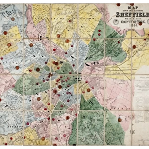

![Plan of the Sheffield Markets, [c. 1826]](/sq/716/plan-sheffield-markets-c-1826-14046487.jpg.webp)