Home > Arts > Artists > B > Babylonian Babylonian
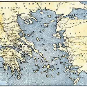
Map of Assyria, Chaldea and Adjacent Countries, 1890. Creator: Unknown

![]()
Wall Art and Photo Gifts from Heritage Images
Map of Assyria, Chaldea and Adjacent Countries, 1890. Creator: Unknown
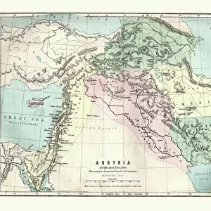
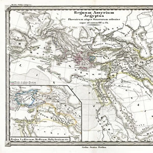
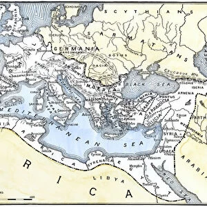
Map of Assyria, Chaldea and Adjacent Countries, 1890. Assyria was a Mesopotamian kingdom from 25th century BC to 612 BC- 609 BC. Chaldea was a country between the late 10th or early 9th and mid-6th centuries BC, after which it was absorbed and assimilated into Babylonia. From " Cassells Illustrated Universal History, Vol. I - Early and Greek History", by Edmund Ollier. [Cassell and Company, Limited, London, Paris and Melbourne, 1890]
Heritage Images features heritage image collections
Media ID 19065557
© The Print Collector/Heritage Images
6th Century Bc 7th Century Bc 8th Century Bc Aged Assyria Babylonia Babylonian Border Cassell And Cassell And Co Cassell And Company Cassells Cassells Illustrated Universal History Early And Greek History Edmund Edmund Ollier Kingdom Mesopotamia Mesopotamian Mesopotamien Ollier Cassell And Company Ltd Chaldea
FEATURES IN THESE COLLECTIONS
> Arts
> Artists
> B
> Babylonian Babylonian
> Arts
> Literature
> Illustration
> Arts
> Literature
> Arts
> Minimalist artwork
> Monochrome artwork
> Fine art
> Arts
> Minimalist artwork
> Monochrome artwork
> Monochrome paintings
> Europe
> France
> Paris
> Maps
> Europe
> Greece
> Related Images
> Historic
> Ancient civilizations
> Ancient Greece
> Greek history
EDITORS COMMENTS
This print showcases a historical treasure, the "Map of Assyria, Chaldea and Adjacent Countries" from 1890. Created by an unknown artist, this map provides a glimpse into the ancient kingdoms that once thrived in Mesopotamia. Assyria, a powerful kingdom that spanned from the 25th century BC to 612 BC-609 BC, is depicted with intricate detail on this aged engraving. Its borders are clearly outlined alongside neighboring regions such as Chaldea. Chaldea itself existed between the late 10th or early 9th centuries BC until its assimilation into Babylonia during the mid-6th century BC. Taken from "Cassells Illustrated Universal History". Volume I - Early and Greek History by Edmund Ollier, this monochrome illustration transports us back to a time when these ancient civilizations flourished. The fine lines and delicate shading evoke a sense of reverence for their rich history. As we gaze upon this antique map, we are reminded of the significant role Mesopotamia played in shaping human civilization. It serves as both an educational tool and a work of art; its presence on our walls invites contemplation about our shared past. The print collector who discovered this gem has preserved not only an important piece of geography but also literature and culture from centuries ago. This remarkable find offers us insight into forgotten worlds while reminding us of humanity's enduring fascination with exploration and discovery.
MADE IN THE USA
Safe Shipping with 30 Day Money Back Guarantee
FREE PERSONALISATION*
We are proud to offer a range of customisation features including Personalised Captions, Color Filters and Picture Zoom Tools
SECURE PAYMENTS
We happily accept a wide range of payment options so you can pay for the things you need in the way that is most convenient for you
* Options may vary by product and licensing agreement. Zoomed Pictures can be adjusted in the Cart.