Home > Asia > Turkey > Related Images
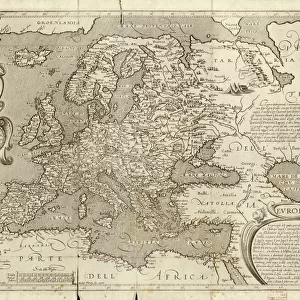
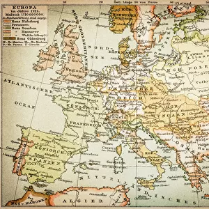
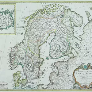
Antique Map of Europe, 1785

![]()
Wall Art and Photo Gifts from Fine Art Storehouse
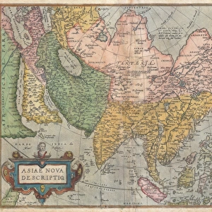
Antique Map of Europe, 1785
An accurate map of Europe from the best authorities. London: C. Dilly & G. Robinson: 1785. Original size: 35.7 x 37.4 cm. Coloured, Inset: Spitsbergen, East and West Greenland, and Iceland. Engraved for William Guthrie
Unleash your creativity and transform your space into a visual masterpiece!
BernardAllum
Media ID 13597639
© Bernard Allum
Backgrounds Baltic Countries Black Sea Continent Denmark Direction Document European Culture Finland Grunge Grunge Image Technique Hungary Latitude Longitude Manuscript Ornate Paper Past Pattern Sepia Toned Social History Square Stained Textured Effect Topography Torn Travel Backgrounds Travel Locations Turkey Turkey Middle East Vector World Map Common Market
FEATURES IN THESE COLLECTIONS
> Asia
> Turkey
> Related Images
> Europe
> Denmark
> Paintings
> Europe
> Denmark
> Related Images
> Europe
> Finland
> Paintings
> Europe
> Finland
> Related Images
> Fine Art Storehouse
> Map
> Denmark Maps
> Fine Art Storehouse
> Map
> Historical Maps
> Fine Art Storehouse
> Map
> Italian Maps
EDITORS COMMENTS
This antique map of Europe, dating back to 1785, offers a fascinating glimpse into the continent's rich history and cultural heritage. Created by esteemed cartographers C. Dilly & G. Robinson in London, this meticulously crafted print showcases the intricate topography and geographical accuracy of its time. Measuring at an original size of 35.7 x 37.4 cm, this beautifully colored map features an ornate design with delicate illustrations and painting techniques that add depth and character to its appearance. The inclusion of insets highlighting Spitsbergen, East and West Greenland, as well as Iceland further enhances its informational value. With its sepia-toned textured effect and subtle stains from years gone by, this vintage piece exudes a sense of nostalgia that transports us back to a different era. Its torn edges remind us of the passage of time while adding an authentic touch to the overall composition. As we explore this historical document, we are taken on a journey across Europe's diverse landscape - from Turkey to Hungary, Baltic countries to Spain, Italy to Germany - each country marked with precision along with significant bodies of water such as the Black Sea. This remarkable map serves not only as a testament to scientific advancements in cartography but also provides valuable insights into past societies and their understanding of geography. A true treasure for enthusiasts interested in European culture or those seeking inspiration from centuries-old craftsmanship.
MADE IN THE USA
Safe Shipping with 30 Day Money Back Guarantee
FREE PERSONALISATION*
We are proud to offer a range of customisation features including Personalised Captions, Color Filters and Picture Zoom Tools
SECURE PAYMENTS
We happily accept a wide range of payment options so you can pay for the things you need in the way that is most convenient for you
* Options may vary by product and licensing agreement. Zoomed Pictures can be adjusted in the Cart.